Martin W. Lawrence - mlawrence@ctbto.org
Comprehensive Nuclear-Test-Ban Treaty Organization
Vienna International Centre, A-1400 Vienna, Austria
Popular version of paper 2aUWa1
Presented Tuesday morning, March 16, 1999
ASA/EAA/DAGA '99 Meeting, Berlin, Germany
The CTBT is the first treaty to ban all nuclear explosion testing and to be backed by an internationally organized global verification system. The CTBT verification system is being established with capability to monitor tests conducted in all terrestrial environments, in order to deter any attempt at evasion of the monitoring system.
The IMS will be capable of detecting, locating and identifying explosions down to sizes of less than 1 kilotonne TNT equivalent, detonated anywhere within the atmosphere, underwater or underground. The System is designed to provide uniform global coverage. Four technologies are being used in the IMS: seismic, hydroacoustic, infrasound and radionuclide. networks of sensors for the four technologies are currently being deployed. The data from each station will be transmitted in real time to an International Data Centre specially constructed in Vienna. The Data Centre will process the data from the 321 IMS stations and produce bulletins of detected events for States Party to the Treaty.
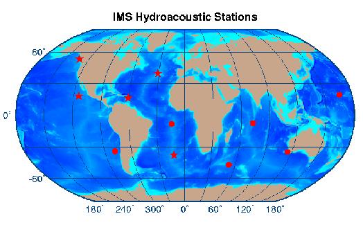
The IMS hydroacoustic network (designed to provide this ocean monitoring) contains just eleven hydroacoustic stations. These stations are located with an emphasis on the Southern Hemisphere, an emphasis that is a natural result of the world's oceans being concentrated in this hemisphere. (In contrast, the seismic IMS network emphasises the Northern hemisphere, as a result of the vast land areas in the Northern Hemisphere.)
There are two quite different types of hydroacoustic stations in the IMS. One method uses hydrophone sensors (underwater microphones in the body of the ocean). This is the most effective technique, but is also quite expensive. The other method uses seismic detectors on small islands (as described below). This technique is not as effective, but it is considerably cheaper. The mix of station types reflects an attempt to get an adequate network at the cheapest cost.
Of the eleven stations that make up the hydroacoustic network, six will be based upon hydrophone sensors. Some key features for these hydrophone stations are as follows. The stations will utilise fixed hydrophones at the centre of the low-loss ocean channel, with a cable bringing the signal back to a shore station. From here the signal will be sent by satellite to the International Data Centre. When these shore stations are on small islands (which is the common situation), there will be hydrophones deployed on opposite sides of the island in order to receive sound from all direction. The hydrophone stations will monitor at the low frequencies (1 to 100 Hz) suitable for recording explosions at large distances.
The other five hydroacoustic stations are located on steep-sloped islands and make use of seismic equipment to detect hydroacoustic waves. In this latter method, the hydroacoustic wave is converted to a seismic wave at the flank of the island (this type of propagation has long been known to the seismic community as T-phase propagation). These T-phase stations are included in the network in order to achieve a significant cost reduction (although with some performance loss in comparison with a fully hydrophone based network).
The location of the eleven hydroacoustic stations is shown in the following figure (the circles are hydrophone stations, the stars are T-phase stations). The locations selected in this network were chosen to achieve maximum coverage of ocean areas together with considerations regarding ease of construction and operation.

Each day the IMS operates will reveal several hundred "events". These events can occur at any location and any time. The characteristics of the signals recorded for these events need to be examined in order to determine if any of them are consist with the "signature" of a nuclear explosion. The hydroacoustic network is particularly effective at discriminating between explosions in the ocean and earthquakes, which are the prime source of detected events. There are two major reasons for this. The first is that if the explosion is contained entirely within the water, the signal displays a characteristic oscillation. The second reason is that the hydroacoustic signal from an underwater explosion, even if not fully contained in water, has far more energy at higher frequencies than does any signal that has propagated through the ground for some distance.
Prior to installation of a station, a site survey is undertaken in order to determine exactly where and how to install it. Site surveys are now complete or underway at a number of stations, including Cape Leeuwin (Australia). Station installation is now underway at the hydrophone stations at Crozet Island (South-West Indian Ocean) and at Chagos Archipelago (North Indian Ocean) as well as the T-phase station at Guadeloupe (Caribbean). Work is planned to soon start on Clarion Island (West coast of Mexico), Juan Fernandez Island (Chile) and Flores Island (North Atlantic Ocean), with Tristan da Cunha (South Atlantic Ocean) to follow.
Certification of operation to CTBT standards will follow installation, leading to operation at a very high level of availability into the indefinite future. The data from all stations will be sent to the International Data Centre in Vienna in real time, 24 hours per day, every day of the year.