[ Lay Language Paper Index | Press Room ]
Marine Seismic Surveys with Vector Acoustic Sensors
Dennis Lindwall- lindwall@nrlssc.navy.mil
Marine Geosciences Division, Naval Research Laboratory
Stennis Space Center, MS 39529
Popular version of paper 5aSP6
Presented Friday morning, June 9, 2006
151st ASA Meeting, Providence, RI
We use sound in the ocean for many things such as mapping the sea floor, locating objects, finding oil and gas, and tracking whales. These applications depend on knowing where the sound came from, i.e., it's direction. For decades we did this by using arrays of hydrophones consisting of 10, 20, 30, or even thousands of hydrophones (in the case of oil exploration). There is another way to measure the direction that sound is traveling that uses a different type of sensor, a "vector sensor", that can allow us to measure the direction of sound with a single, miniature device. Watch the animation below (it works best if you can loop it):
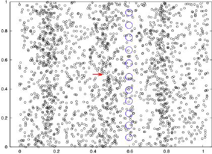
This illustrates how sound waves travel through water or air. All the little black circles are molecules of water or air. They move back and forth as the sound waves pass by but they have no net motion. The red arrow represents how a motion sensor that measures this back and forth motion will indicate the direction that the sound is traveling. The line of blue circles represents an array of hydrophones, like what we use now, and they pulse as the pressure rises and falls. When they pulse in sync like this, we know that the sound is hitting them broadside. The single vector sensor not only replaces the entire hydrophone array but gives us even better information.
Ah! But the vector sensor points in two directions. We can rectify this by using a single hydrophone (usually attached to the vector sensor) and I go through the mathematics of this as well as how I generated the 3-D images and show examples in my talk. The hydrophone array hit broadside can't tell which side the wave came from.
Last year I, along with colleagues at NRL in DC and NUWC in Newport, did an experiment in a large tank of water to test the concept of imaging the environment with a vector sensor. We used an accelerometer-based vector sensor designed specifically for use in water by Roger Richards and others of the NAVSEA division of NUWC in conjunction with Wilcoxon Research Inc and suspended it near the center of the pool with thin elastic strands. To reduce the problem of multiple sound reflections arriving at the same time, we moved our sound source around to several locations. Here is a drawing of our setup:
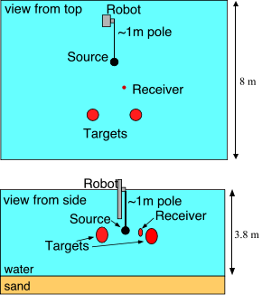
This was a 3-D environment with flat surfaces (tank sides, water surface and bottom) and small objects. We wanted to make an acoustic 3-D image with all of these features. The "targets" were air-filled rubber floats that are used to hold up fishing gear or scientific instruments. The robot could move our sound source around to various positions in the tank. Here are some slices of our 3-D image.
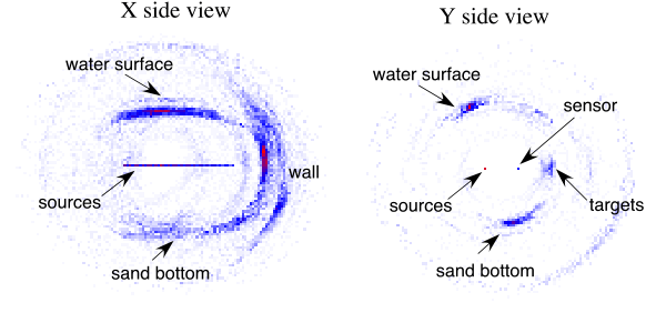
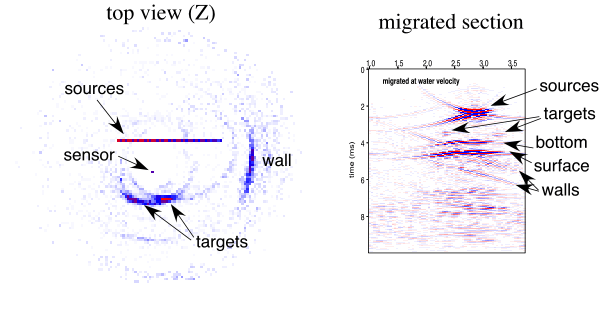
The "migrated section" is the best that we can do without the vector data, using only a hydrophone array, which is the technique that is widely used today. The vector data puts all of the surfaces and objects in the correct 3-D position while the best results from hydrophone data smashes everything (top, bottom, sides, targets) onto a 2-D surface.
Here is another animation of the 3-D volume image. Each frame is a horizontal slice through the tank starting from just below the sand bottom and moves upward past the targets to just above the water surface. Drag the slider back and forth so that you can control the movement. The source and sensor positions are not marked but are at the same level as the targets.
The applications of vector acoustic sensors in the future may bring profound changes to the way that we use sound to explore the ocean and the geological features beneath the seafloor. Currently, oil-exploration seismologists go to extraordinary means to get accurate 3-D seismic images of their prospects and their instrumentation and logistics could be drastically simplified with vector acoustic sensors. Seafloor mappers struggle to combine their acoustic images with bathymetry and this could be done with a single instrument using vector acoustic sensors. The best whale tracking systems use the recently declassified SOSUS arrays that could be replaced by simple and portable vector acoustic sensor instruments. The listing could go on and on. All of these new applications, however, will depend on both continuing sensor development and data processing methods. Vector acoustic sensors give us three data dimensions where we previously had one and making the most of this additional information is the challenge that brought some of us to this meeting.
This work would not have been possible without the loan of a TV-001 sensor as well as the technical expertise of Roger Richards from NAVSEA division of the Naval Underwater Warfare Center. The experimental set up regarding the tank configuration and data acquisition was done by Harry Roberts of NRL. This work was funded by the Office of Navel Research program element 61153N.
[ Lay Language Paper Index | Press Room ]